December 29, 2025
This central São Tomé travel guide covers the Mé-Zóchi district, rising inland from the capital toward the island’s volcanic highlands. The route follows the EN1, the main artery connecting São Tomé city with the interior. Within roughly 20 kilometres, elevation climbs from sea level to well over 1,000 metres, making this the most dramatic altitude transition on the island.
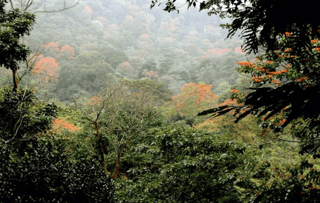
Central São Tomé is defined by vertical relief, frequent cloud cover, and high rainfall. These conditions shaped the region’s historic role as the centre of plantation agriculture, particularly coffee. Steep valleys, ridgelines, and secondary forest dominate the landscape, much of it structured by the colonial roça system that reorganised land, labour, and settlement patterns from the nineteenth century onward.
Compared with the drier north, temperatures here are noticeably cooler and weather can change quickly. Mist and rain are common, especially in the afternoon. The agricultural infrastructure built to exploit these conditions remains visible and functional, linking the area’s present-day communities directly to its colonial past.
If you are planning to explore the highlands, you can view our tours or tackle the gradients independently with our car hire.
As a core feature of any Central São Tomé Travel Guide, Café is a former plantation village founded in 1858 and remains the island’s most significant centre for Arabica coffee production. Rather than a single attraction, it functions as a working settlement organised around the original plantation core.
The Museu do Café occupies part of the historic estate and documents the full production cycle, from cultivation through processing and export. A local guide will walk you through, but to be honest, do not expect a great deal of insight; they work from learned scripts and the performance is lacklustre. If you want to learn more, check out our roça guide or history page.
Large concrete drying patios, known locally as terreiros, are still used, and the original administrative buildings and worker housing remain structurally intact. At the end of the tour, you will be taken to a small shop where you are given the chance to try some local coffee. Weirdly, although they grow two types of coffee (Robusta and Arabica), you are not provided with the opportunity to try both, and the coffee is served from a machine. Furthermore, the coffee and chocolate sold here are available for lower prices elsewhere on the island.
These spaces are not preserved as static exhibits but are embedded in daily life, offering a rare view of how a colonial estate evolved into a post-independence community. Monte Café also serves as a primary gathering point for shared local transit to the surrounding highlands, making it a natural pause point rather than a final destination.

Cascata de São Nicolau sits on a steep uphill branch route in the central highlands. You climb to reach the waterfall, and the road continues climbing beyond it towards the São Nicolau area. The falls themselves drop around 30 metres over a basalt escarpment, with a bridge crossing the stream at the base.
There is a wooden bridge down to the falls, as shown in the image above, but it’s lethal, the wood becomes slippery with algae and I’ve seen quite a few nasty tumbles, be careful if you go down. There’s some wonderful artwork around the falls, and a reasonably priced souvineer seller there too.
Access involves narrow bends with a steep drop on one side and a steep, vegetated slope on the other. After rain, leaves and small branches often collect on the surface, and traction can be poor. Drive slowly on the approach and through the bend by the bridge, especially in mist.
Along this stretch, children sometimes sell utjeu, small raspberry-like berries scooped into paper cones. They may step into the road to get your attention, so expect sudden movement on blind corners. If you buy, avoid school hours so tourism does not encourage truancy. You can also pick utjeu from shrubs just above the roadside, but the slope is slick, even a few metres up is enough for a fast slide back down, and wet muddy clothes are a miserable drive.

Bom Sucesso lies at the upper limit of regular road access and serves as the operational gateway to Ôbo Natural Park. At over 1,100 metres, the site sits within a cloud forest zone, characterised by persistent humidity, lower temperatures, and dense endemic vegetation. This is a vital stop on this Central São Tomé and Principe travel guide.
Travel through central São Tomé is shaped by terrain rather than distance. Adopting a leve leve pace is essential for safety, especially given the lack of road sense from local pedestrians and the poor traction on wet slopes. You may be a highly experienced driver, but our roads, children, leaves and pigs are a great leveller. Follow all the tips in this central São Tomé and Principe travel guide and you should be ok.
Road conditions: The EN1 is paved but steep, with tight bends and regular slow-moving traffic. As noted, the branch road to the falls is prone to debris from the slopes above. The road is generally pretty good, by island standards up to the top, but the side routes are ‘fun’.
Weather and nebina: High elevations are prone to nebina, a thick mountain mist that can reduce visibility to less than 10 metres and leaves the road surface, particularly around the Cascata de São Nicolau bridge, perpetually slick.
Vehicle choice: A high-clearance vehicle is strongly advised, particularly beyond Monte Café. A 4WD becomes important during the rainy season when fog, runoff, and reduced traction are common.
Supplies: Fuel, cash, and provisions should be secured in the capital. Services in the highlands are limited to small local stalls and facilities at Monte Café
This central São Tomé travel guide covers a region defined by altitude, climate, and production. From the industrial legacy of Monte Café to the research-driven landscape of Bom Sucesso, the interior reveals how geography shaped both colonial exploitation and modern conservation. It is not a scenic detour but a core route for understanding how São Tomé functions beyond its coastline.
Need Advice?